Posts

Showing posts with the label Aerial imagery

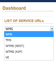
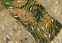
How To Work Remotely with FBS Imagery

Image
We'll hook you up! We're still flying. As an essential part of the supply chain for other businesses to continue operations, First Base is practicing physical distancing while remaining open. If your work place is doing the same, rest assured the aerial imagery services you rely on for mapping projects will continue to be provided as usual. Are you working from home? If your new work arrangement includes remote desktops, VPN, or some other work around to support a remote work force, your geospatial needs may have changed as well. Luckily there's more than one way to access our imagery: MapWarehouse , VuMAP , and MapCast.

Best of the Zoo! [Photoblog]

Image
School's out on Monday and the kids are acting like caged animals? Take them to see these amazing creatures. A few of the best shots from around the Toronto Zoo captured over the last few years in our aerial imagery.

What Can I Do With 8 Band Imagery?

Image
512 RGB Visualizations to choose from The satellite imagery we provide is often ordered as "natural colour" with red, green, and blue spectral bands to simply provide a base layer for mapping in areas where aircraft sourced orthophoto is not available or not current enough. For more sophisticated applications, multi-spectral imagery with 4 bands or 8 bands can be ordered to view imagery in "false colour".

Great Lakes' Great Beaches [Photoblog]

Image
Civic holiday is here! Before you could easily whisk away to the Caribbean for a tropical vacation, local beach towns were in their hay day with boardwalks, hotels, and tourist amenities of all kinds. Explore your options below before hitting the road with this beaches orthophoto tour around the Great Lakes shoreline.

No Metadata? No Problem.

Image
Where did the imagery come from?  Even with limited information, a trained eye can glean clues in aerial imagery to learn more about it's origin. If this is your first time working with remote sensing data, here's some tips to research and interpret aerial imagery to make sure you've got the latest and greatest.

MapCast Troubleshooting Checklist

Image
Have you tried turning it off and turning it back on again? The top roadblocks to success with your MapCast subscription and how to address them. In general terms, these checklists are the most relevant questions to ask to solve the most common issues when getting started with MapCast in any type of CAD or GIS. Consult your software's help files for specific instructions.

RAQ: How To Get The Newest Data First

Image
Is it ready yet? ...How about now? ...Now? The aerial imagery collection window in Ontario is short for the most popular leaf-off ortho products, around 6-8 weeks. Typically we can start flying in late March and it all wraps up by early May, weather dependent. In this time frame we cover a lot of ground, often capturing imagery for several municipalities. Once the intense flying season is over, the next six months are spent back at the office processing the raw images into an application-ready mosaic and posting the data to the MapWarehouse store, VuMAP , and MapCast . During this six month period we frequently get asked, "Is it ready yet? ...How about now? ...Now?" There are three ways you can keep in the loop when new data is released.

RAQ: How Does Image Resolution Relate To Map Scale?

Image
Will it Work?  First, 20cm imagery is not the same as 1:20 map scale. Maps are created with mix and match combinations of data sources. Each source may be fine on its own, but will the information make sense in the final composition? If you trust the source data providers are reliable and you've got a handle on the datum and projection issues but the finished map looks awful, consider mismatches in scale.

WMS? TMS? WMTS? MapCast Subscribers Take Your Pick

Image
An explanation in plain English without the WTF As a new subscriber to MapCast, you'll need to connect to the service before you can get to work. On the MapCast dashboard there are five options. Here I'll recommend which connection type to use and when. Your service connection type will depend on the software you plan to use. First, a quick overview of what you can do with MapCast based on the connection type you choose. In all cases, MapCast delivers image tiles at various scales which are displayed in turn as the user zooms in or out.  The user has access to view the data, not direct access to the data itself, therefore, it can not be manipulated , saved or edited.

Rarely Asked Questions: How To Use A Tile Map Service

Image
If you can use Google Maps, then you're already an expert. It's much easier than you think. What's a TMS? TMS is a Tile Map Service. Aerial imagery from our planes is processed to create a highly detailed photo map that covers Southern Ontario. A grid is used to split the photo map into thousands of small tiles.

Zoom2It Demo [Video]

Image
How to search for Ontario aerial imagery with Teranet property boundaries If you're new to Zoom2It , welcome! The most common questions from new users include 'How do I get the images I just bought' and 'How can I open this file?' Here's a few quick hints.

Decision Guide: Ground or Aerial Survey?

Image
Quick Answer: Both! Detailed topographic mapping from our MapWarehouse archives is popular with civil engineers to model terrain in 3D. Users can predict the flow of surface water, air movement, acoustic modeling, sight line analysis, make volumetric calculations, and even show depth on a flat image when used together with orthophoto. Most big projects, however, also have a ground survey component. Why buy DEM or contour mapping if you need a survey anyway? One's not better than the other, they both have their place in the project life cycle. Take a detailed look:

Crash Course: Elevation Imagery

Image
Sample contours map Find the right elevation imagery for your needs Elevation imagery from FBS is usually sold as either DEM with spot heights and break lines, or, as 1m interval contour lines derived from those DEM, but, we have a few other products you might not know about. As you can see in the chart, there are five products that you can extract elevation data from. Each has different types of deliverable's, precision, and geographic coverage:

Crash Course: Orthophoto Imagery

Image
High Resolution Orthophoto Imagery What is Orthophoto imagery? An Ort hophoto imagery is aerial imagery that has been digit ally corrected to be perfectly in scale. What Does This Mean?  This means all overhead perspectives are in uniform, You can draw on it, measure objects within the image with extreme accuracy; just like a conventional map. It is capable of measuring true direction and distances free of any distortions that may have been caused by the aircraft.

New Toronto Spring 2016 Orthophoto Data Added!

Image
Just in time for the winter thaw, we are proud to announce the addition of  new orthophoto data for the city of Toronto. Our fleet of Cessna's were able to take several flights across the city during the Spring of 2016, capturing every detail of the city from a controlled and consistent elevation. Many changes can happen in just a short year throughout the city, if your organization depends on land usage and development, then having the most recent data is absolutely critical to maintaining your competitive advantage.

What can we expect from GIS in 2017?

Image
Top 6 trends of 2016 With 2016 now behind us, it’s now time to look ahead, and discuss what industry experts predict to be the prevailing trends for GIS and Geo-Spatial Technologies for 2017, and more importantly, what it means for you and your business. Lets begin by looking at the prevailing long term trends that should continue through the next 5 years. Then we will identify the short-term 2017 trends that are expected to grow.

Rarely Asked Questions - Isn't There Anything Newer?

Image
The data isn't old, it's established Fifteen years isn't long in geological time. So is it really worth your time to look for updated mapping if you're only interested in geological features or other map data that won't change at all in your relatively short human lifetime? Probably not. One question we often get from customers is, "Don't you have anything newer?"

Our Newest High Value Data Partner, Tarin Resource Services

Image
East Meets West First Base Solutions is pleased to announce we have recently entered a partnership with Tarin Resource Services of Alberta.  In the coming months, First Base customers will see Tarin's aerial imagery covering Alberta added to our MapWarehouse store and MapCast WMS alongside our own Ontario data sets.

Get Lost! [Photoblog]

Image
Fun on the farm Ontario farms have expanded into family entertainment destinations in the last few years - and it's not just your typical hay rides anymore. Check out these large scale corn maze designs from the air!

$100 Not Going As Far As It Used To?

Image
Best $100 per month investment for your business For a lot of us, $100 is a tank of gas. If you use that $100 tank of gas to drive your crew and equipment out to investigate various work sites, add your labour costs, plus any lost opportunity costs while your assets and gear are tied up on the road. That $100 tank of gas actually costs your business far more than face value.