Posts

Showing posts with the label engineering

Decision Guide: Ground or Aerial Survey?

Image
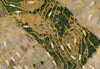
Quick Answer: Both! Detailed topographic mapping from our MapWarehouse archives is popular with civil engineers to model terrain in 3D. Users can predict the flow of surface water, air movement, acoustic modeling, sight line analysis, make volumetric calculations, and even show depth on a flat image when used together with orthophoto. Most big projects, however, also have a ground survey component. Why buy DEM or contour mapping if you need a survey anyway? One's not better than the other, they both have their place in the project life cycle. Take a detailed look:

Crash Course: Elevation Imagery

Image
Sample contours map Find the right elevation imagery for your needs Elevation imagery from FBS is usually sold as either DEM with spot heights and break lines, or, as 1m interval contour lines derived from those DEM, but, we have a few other products you might not know about. As you can see in the chart, there are five products that you can extract elevation data from. Each has different types of deliverable's, precision, and geographic coverage:

New Toronto Spring 2016 Orthophoto Data Added!

Image
Just in time for the winter thaw, we are proud to announce the addition of  new orthophoto data for the city of Toronto. Our fleet of Cessna's were able to take several flights across the city during the Spring of 2016, capturing every detail of the city from a controlled and consistent elevation. Many changes can happen in just a short year throughout the city, if your organization depends on land usage and development, then having the most recent data is absolutely critical to maintaining your competitive advantage.

Rarely Asked Questions - Isn't There Anything Newer?

Image
The data isn't old, it's established Fifteen years isn't long in geological time. So is it really worth your time to look for updated mapping if you're only interested in geological features or other map data that won't change at all in your relatively short human lifetime? Probably not. One question we often get from customers is, "Don't you have anything newer?"

$100 Not Going As Far As It Used To?

Image
Best $100 per month investment for your business For a lot of us, $100 is a tank of gas. If you use that $100 tank of gas to drive your crew and equipment out to investigate various work sites, add your labour costs, plus any lost opportunity costs while your assets and gear are tied up on the road. That $100 tank of gas actually costs your business far more than face value.

Got Waterfront?

Image
To develop, or not to develop in the floodplain? I often get calls from developers, engineers, and regular home owners looking to make a few changes to their properties. If that property is crossed by a water feature, you may need to apply for a Development, Interference with Wetlands and Alterations to Shorelines and Watercourses permit in the course of having a development application approved.

Is Your Job On Track Or Off The Rails?

Image
Work full steam ahead with aerial imagery Follow our crew as they bravely travel great distances and battle the perils of the wilderness, blazing sun, and mosquitoes as big as your head to inspect remote infrastructure...the old way.

VuMAP Tutorial: VIEW, QUERY, MEASURE, REPORT

Image
Learn your way Watch the video or or follow the script below. The video is split into 4 parts: View, Query, Measure, Report. View: learn the basics Query: tools for researching property information Measure: tools for planning and projects Report: importing, exporting, sharing, and printing    Related: Saving, Surfing, or Streaming? How to choose the data delivery method that's right for your project

Three Ways To Use Spatial Data For Development

Image
Solutions for engineering & property development Get the best possible results from your development site with the help of aerial imagery, topographic models, and other spatial data. Use the insights you gain from our high resolution orthophoto to ease communication with stakeholders and support critical decisions.