What can we expect from GIS in 2017?
 |
| Top 6 trends of 2016 |
With 2016 now behind us, it’s now time to
look ahead, and discuss what industry experts predict to be the prevailing
trends for GIS and Geo-Spatial Technologies for 2017, and more importantly, what it means for you and your business.
Lets begin by looking at the prevailing long term trends that should continue through the next 5 years. Then we will identify the short-term 2017 trends that are expected to grow.
1. Increase
in connectivity
It’s no secret that connectivity on a
global scale is increasing exponentially. Cisco predicts that by 2020, there will be over 50 billion devices connected to the internet; that’s 7 devices for every person on Earth! With every device having multiple sensors, many analysts
predict that this unprecedented level of connection will create an "Internet of Everything", an ecosystem composed of trillions of sensors. Imagine the
information that would be readily available, and the problems we could analyze
and solve instantly.
 |
| Credit: Cisco |
Now, this may sound like something straight out of a
science-fiction movie, but consider the rapid proliferation of smart phones and
wearable tech. Now that these
technologies have matured, they will be cheaper and more readily available
globally, it would be logical to assume that the next 3 years will see an even
faster rise of global connectivity.
With all of this overwhelming location data
being streamed from devices, GIS will make enormous advancements and will
become absolutely critical in making intelligent business decisions.
2. Big data and the cloud
Big data is becoming increasingly more
common, and even more importantly, more socially accepted. What does this mean?
Metadata is the pulse that energizes the
heart of GIS. The more that is collected, the more vibrant the pulse.
Possessing this awesome processing power allows us to analyze and come to
conclusions that are far more accurate, objective and quicker.
The cloud plays a complementary role by
providing access on an enormous scale. Storing this massive amount of metadata
in one central location fosters collaboration and speed of analysis. Take the
example below.
Scientists from Geoscience Australia have
deciphered 25 years of satellite imagery thanks to big data and the cloud.
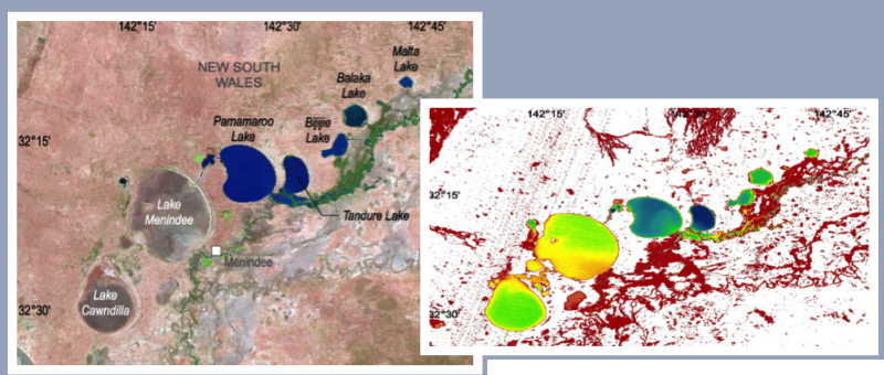 |
| Credit: CRCSIC 2017 report |
The map is color coded to show the
hydrological features of the regions.
- Red represents areas that hold water 1% of the time;
- Green areas are 20% of the time;
- Blue areas hold water 100% of the time.
Think about how this can be used into
practice from analyzing the features of an infectious disease, or analyzing
demographics for an optimal business location. We expect 2017 to see an increase in
usage by organizations of big data and storing their information on the cloud.
What about trends specific to 2017? We have identified these trends that are poised to grow and mature this year.
3. Collaboration
With all of these new capabilities, and the
overwhelming amount of data needing to be processed, collaboration will be a critical
need for the future, and we expect this area to grow substantially in 2017. Organizations
that fail to collaborate will run the risk of repeating work; make slower
progress, and just overall inefficiencies.

According to a report from Deloitte,‘Collaborative Economy’ valued collaboration at A$ 9.3 billion per year, found
that companies that collaborate are up to five times more likely to grow, twice
as likely to be profitable, and twice as likely to outgrow competitors. Yet it
also found that half of the businesses surveyed have no collaboration strategy.
First Base Solutions looks to solve this
problem by ensuring collaboration is integrated into our products, allowing team
members to share resources and information in the most efficient way possible.
4. Open Source
2016 has seen a continued trend of
governments at every level making GIS data available for public consumption.
Even here in Ontario, municipalities have been sharing this data on their
websites. You probably used these
services yourself in the past year. They are your park locators, snow-plow
trackers, zoning maps, city service locators and etc. They are already
ubiquitous in everyday governance and serve a great purpose in creating
transparency in the interest of making their citizens more informed about the
community they live in.
This trend should continue through 2017, with an increase of the types of metadata available for public consumption. This is where organizations like First Base Solutions, will be critical in acquiring imagery and data on behalf governments and other organizations.
This trend should continue through 2017, with an increase of the types of metadata available for public consumption. This is where organizations like First Base Solutions, will be critical in acquiring imagery and data on behalf governments and other organizations.
5. Automation
Automation is another trend expected to
continue throughout the new year. With the rise of the other factors noted above, one
way of processing this large amount of data is through automation. More complex
automated processes are expected to be utilized in 2017, with more accurate and
powerful scripts, and through complex 3D models and algorithms. Soon manually
processing data will be a thing of the past.


6. Integration
2016 saw an explosion of GIS, and other
location-based technologies enter the mainstream audience. Mobile apps like Pokémon
GO integrated GIS with online gaming set the internet on fire with its virility;
surpassing 100 million downloads in under a month!
We project that this trend will continue
strongly, and we will see mass integration of location based technologies with many
other applications, including gaming, marketing, and predictive analysis. Organizations
should be looking at GIS as a critical business transformation tool to make
intelligent business decisions, and we predict that more organizations will
come to this realization in 2017.
Start Today!
If your New years resolution is to cut down on waste and other inefficiencies, harnessing the awesome power of GIS will allow your organization to do more with less, this is the place to get started!


Comments
Post a Comment