Posts

Showing posts with the label Digital Globe

Crash Course: Elevation Imagery
Image
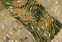
Sample contours map Find the right elevation imagery for your needs Elevation imagery from FBS is usually sold as either DEM with spot heights and break lines, or, as 1m interval contour lines derived from those DEM, but, we have a few other products you might not know about. As you can see in the chart, there are five products that you can extract elevation data from. Each has different types of deliverable's, precision, and geographic coverage:

Budget Buster! Take Advantage of this Great Deal!

Image
Time to start breaking the bank! Maximize that budget you have leftover with this incredible deal from First Base Solutions.  From February 1st to March 31st 2017 ,  If you purchase a 1 meter contours or DEM data on MapWarehouse, you will receive an additional 20% off any vintage orthophoto (below 2015) imagery! This is your chance to act now if you want to combine DEM or Contours with orthophoto imagery for a more complete and detailed view of your area of interest!

Friday Fun Crossword

Image
Spelling FBS out for you Clues and answers are below. Don't cheat! (All the answers can be found on firstbasesolutions.com )

Satellite Sale!

Image
Get up to 35% off 30cm imagery Earlier this year, DigitalGlobe moved the industry a major step forward with the introduction of 30 cm imagery. Our customers can experience this groundbreaking product at promotional pricing which takes effect immediately and continues through December 31, 2015. Under this program, the price of 30cm imagery has been reduced by up to 35%.

Let's Make A Deal

Image
How to sell your geospatial data through MapWarehouse We've got aerial imagery in spades. It makes a great base for many types of projects such as pre-engineering work, estimating material costs, or just to add context to your line drawings, but we know there's lots of quality data out there that would complement what you already find on MapWarehouse. That's where you come in. Related: The Essential Cheat Sheet For Purchasing Digital Geo Data

How The Insurance Industry Benefits From Mapping Technology

Image
Improved data provides important insights in critical situations. Insurance is a data driven industry.  First Base Solutions has tools that help you understand the current situation, avoid hazards, and forecast accurately using aerial imagery and spatial data.

Spatial Data Expedites Environmental Protection

Image
How spatial data is being used in natural resources & environmental applications. Canada is big. Our watersheds and forest corridors cover vast areas, often spanning several administrative regions. For this reason, it can be difficult to effectively monitor and communicate the conditions of the environment as it changes, and also difficult to reach consensus on a plan of action and coordinate on policies between jurisdictions. Lack of coordination between regional governing bodies, short sighted planning and rapid land development have been the peril of the natural environment over the last 100 years or more. Habitat loss, erosion, soil and groundwater depletion and contamination have all taken a toll, and now ambitious plans to mitigate further damage are needed to aid recovery, not just for the intrinsic value of nature, but also for the sustainability of food production, water, air and climate.

Three Questions To Ask Yourself Before Purchasing Aerial Imagery

Image
Shopping is hard. How to decide? So, you’ve seen your competition submitting proposal after proposal with stunning maps and images detailing the planned work. Even though your idea is better, you’re having trouble expressing clearly what you can do to the decision maker whose probably spending a minimal amount of time flipping through each proposal and needs to be impressed quickly.

Our Data

Image
What's in store? From Governments to Google, for the last 15 years, First Base Solutions has been the primary source for geospatial data and aerial image acquisition in Ontario. You might not know our name, but you definitely know our data.

WorldView-3: Launch Day!

Image
Watch live coverage of the launch     Markham, ON, Wednesday, August 13, 2014 – With just a few hours left, we are eagerly anticipating the launch of WorldView-3, DigitalGlobe’s most sophisticated high resolution imaging satellite ever put into orbit! Watch the launch live August 13, 2014 from Vandenberg Air Force Base, California at 2:30 p.m. EDT via the ground-to-orbit webcast provided by United Launch Alliance. Tune in about 20 minutes early and you’ll be able to hear the countdown!

Ever Thought About Incorporating Satellite Imagery In Your Projects?

Image
How to Source Commercial Satellite Imagery When Google Earth was launched in 2005, high resolution satellite imagery suddenly became easily accessible to anyone with an Internet connection.  Much of this high-resolution imagery (50-60 cm) is provided by Digital Globe and can be used for a wide range of commercial applications such as urban planning, engineering, utilities and more.  Satellite imagery is a great option for mapping large, remote or inaccessible areas where orthophoto is not available.  So, how is the imagery captured, and how can a commercial user purchase the imagery?