WMS? TMS? WMTS? MapCast Subscribers Take Your Pick
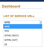
An explanation in plain English without the WTF As a new subscriber to MapCast, you'll need to connect to the service before you can get to work. On the MapCast dashboard there are five options. Here I'll recommend which connection type to use and when. Your service connection type will depend on the software you plan to use. First, a quick overview of what you can do with MapCast based on the connection type you choose. In all cases, MapCast delivers image tiles at various scales which are displayed in turn as the user zooms in or out. The user has access to view the data, not direct access to the data itself, therefore, it can not be manipulated , saved or edited.