Posts

Showing posts with the label contour

Crash Course: Elevation Imagery

Image
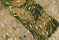
Sample contours map Find the right elevation imagery for your needs Elevation imagery from FBS is usually sold as either DEM with spot heights and break lines, or, as 1m interval contour lines derived from those DEM, but, we have a few other products you might not know about. As you can see in the chart, there are five products that you can extract elevation data from. Each has different types of deliverable's, precision, and geographic coverage:

Rarely Asked Questions - Isn't There Anything Newer?

Image
The data isn't old, it's established Fifteen years isn't long in geological time. So is it really worth your time to look for updated mapping if you're only interested in geological features or other map data that won't change at all in your relatively short human lifetime? Probably not. One question we often get from customers is, "Don't you have anything newer?"

MapCast Tutorial

Image
You'll laugh, you'll cry, you'll learn! If you want to quickly learn how to use a WMS (web mapping service) to stream aerial imagery and geographic data into your desktop GIS or CAD software, or just want to improve your skills and learn a few tricks of the trade, this video will get you up to speed quickly with real world examples. Watch the videos and follow the transcript below.

Free Bandwidth To Experiment With MapCast

Image
Hurry, this deal ends September 30, 2016  If you've thought about trying MapCast , now's the time. MapCast gives you unlimited access to Ontario's largest WMS (web mapping service), delivering a base layer of current and historical high resolution aerial imagery and elevation contours directly into the CAD or GIS software you already use. Simply add data to your map project and choose a connection to MapCast instead of data stored locally. Connect to MapCast with the software you already use! Learn More: Download the MapCast Sellsheet

MapCast: Imagery On Demand

Image
Unlimited access to Ontario's largest web mapping service Access all of First Base Solutions' aerial imagery and elevation contours served directly into your desktop CAD or GIS software with MapCast. Connect to MapCast with the software you already use!

All About Custom Mapping & Terrain Models

Image
Taking flat images to new heights About Where the most current mapping data possible is required for site development, asset inventories, or land use planning, First Base Solutions is well equipped to undertake complex, highly detailed custom mapping of your site. We offer full service map production beginning with acquiring custom aerial imagery from our own aircraft to ensure the features in the final mapping are up to date and at the level of detail you need. We delineate the ground feature types you request, and even produce 3D digital models of the terrain . All this comes at a fraction of the price of labour-intensive field surveys and traditional mapping methods.

Bumps In The Road? We've Got Mapping For That [Cheat Sheet]

Image
Finding terrain mapping can be an uphill battle Elevation data from FBS is usually sold as either DEM with spot heights and break lines, or, as 1m interval contour lines derived from those DEM, but, we have a few other products you might not know about.

Have GPS, Will Travel

Image
Pull new insights from your GPS data to guide smart decision making with better base maps.

Friday Fun Crossword

Image
Spelling FBS out for you Clues and answers are below. Don't cheat! (All the answers can be found on firstbasesolutions.com )

Is Your Job On Track Or Off The Rails?

Image
Work full steam ahead with aerial imagery Follow our crew as they bravely travel great distances and battle the perils of the wilderness, blazing sun, and mosquitoes as big as your head to inspect remote infrastructure...the old way.

Power Up Your Communication With Remote Workers

Image
Can you see the forest for the trees without the aerial imagery? Follow our crew as they bravely travel great distances and battle the perils of the wilderness, blazing sun, and mosquitoes as big as your head to inspect remote infrastructure...the old way.

Paving The Way For Profit

Image
Optimize business processes immediately with hands-on mapping technology Pop quiz: A commercial customer contacts you for a quote to repave a parking lot. What do you do next?

How The Insurance Industry Benefits From Mapping Technology

Image
Improved data provides important insights in critical situations. Insurance is a data driven industry.  First Base Solutions has tools that help you understand the current situation, avoid hazards, and forecast accurately using aerial imagery and spatial data.

Maps Let Citizens Get Involved

Image
Mapping technology for urban planning & municipal governments. With so many competing interests to consider, how can municipal planners design the best future for their city that respects the environment, addresses social needs and creates community engagement?  First Base Solutions provides custom solutions integrating high resolution aerial imagery with interactive mapping tools for public and internal use.

Three Ways To Use Spatial Data For Development

Image
Solutions for engineering & property development Get the best possible results from your development site with the help of aerial imagery, topographic models, and other spatial data. Use the insights you gain from our high resolution orthophoto to ease communication with stakeholders and support critical decisions.

Options For Managing Infrastructure Networks

Image
Solutions for energy, utilities, service delivery, infrastructure and more. It doesn't matter what you're delivering, if you have widespread networks and facilities to monitor and maintain, you need a fool proof system in place to stay on top of it all. First Base Solutions is a provider of off the shelf and custom mapping solutions to fit your business needs, technical ability and budget.

What You See Is What You Get?

Image
Governments Lie? Even though scientists tell us that the polar ice caps are melting at an alarming rate, the new Atlas of Canada tells a different story because the methodology of calculating sea ice has changed. Mark Monmonier's library of publications, the best known being How to Lie with Maps outlines this principle in detail. We don't condone dishonesty, of course, but you can emphasize the point you want to make, draw attention to certain features, or influence an audience like your stakeholders by presenting spatial data in a way that best supports your position.

Our Data

Image
What's in store? From Governments to Google, for the last 15 years, First Base Solutions has been the primary source for geospatial data and aerial image acquisition in Ontario. You might not know our name, but you definitely know our data.

MapWarehouse... Search, Select, Download, Work!

Image
MapWarehouse is Ontario's largest geospatial data marketplace! Watch the video or follow the screen images below to learn how to: SEARCH For your area of interest and search for data coverage at your site. SELECT Review the options available. DOWNLOAD Complete the transaction details. WORK Get started with using our data. Related: Saving, Surfing, or Streaming? How to choose the data delivery method that's right for your project