Posts

Showing posts with the label WMS

No Metadata? No Problem.

Image
Where did the imagery come from?  Even with limited information, a trained eye can glean clues in aerial imagery to learn more about it's origin. If this is your first time working with remote sensing data, here's some tips to research and interpret aerial imagery to make sure you've got the latest and greatest.

MapCast Troubleshooting Checklist

Image
Have you tried turning it off and turning it back on again? The top roadblocks to success with your MapCast subscription and how to address them. In general terms, these checklists are the most relevant questions to ask to solve the most common issues when getting started with MapCast in any type of CAD or GIS. Consult your software's help files for specific instructions.

Wrapping Up 2018

Image
What's new, what's coming In 2018, we accomplished important behind-the-scenes work in preparation for the upcoming launch of MapCast 2.0 in 2019. We also got to work developing relationships with data providers to bring new value-added mapping products to our MapWarehouse store as well as producing a library of mini tutorials to help you use them.

WMS? TMS? WMTS? MapCast Subscribers Take Your Pick

Image
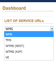
An explanation in plain English without the WTF As a new subscriber to MapCast, you'll need to connect to the service before you can get to work. On the MapCast dashboard there are five options. Here I'll recommend which connection type to use and when. Your service connection type will depend on the software you plan to use. First, a quick overview of what you can do with MapCast based on the connection type you choose. In all cases, MapCast delivers image tiles at various scales which are displayed in turn as the user zooms in or out.  The user has access to view the data, not direct access to the data itself, therefore, it can not be manipulated , saved or edited.

Rarely Asked Questions: How To Use A Tile Map Service

Image
If you can use Google Maps, then you're already an expert. It's much easier than you think. What's a TMS? TMS is a Tile Map Service. Aerial imagery from our planes is processed to create a highly detailed photo map that covers Southern Ontario. A grid is used to split the photo map into thousands of small tiles.

MapCast Tutorial

Image
You'll laugh, you'll cry, you'll learn! If you want to quickly learn how to use a WMS (web mapping service) to stream aerial imagery and geographic data into your desktop GIS or CAD software, or just want to improve your skills and learn a few tricks of the trade, this video will get you up to speed quickly with real world examples. Watch the videos and follow the transcript below.

Free Bandwidth To Experiment With MapCast

Image
Hurry, this deal ends September 30, 2016  If you've thought about trying MapCast , now's the time. MapCast gives you unlimited access to Ontario's largest WMS (web mapping service), delivering a base layer of current and historical high resolution aerial imagery and elevation contours directly into the CAD or GIS software you already use. Simply add data to your map project and choose a connection to MapCast instead of data stored locally. Connect to MapCast with the software you already use! Learn More: Download the MapCast Sellsheet

How To Reference Digital Maps as Cited Works

Image
Beyond the book report If you need to reproduce a section of our maps and imagery to incorporate into your design proposal, research results, or similar professional documentation, spare a little room in your composition to cite your data sources correctly.  It not only fulfills the legal requirements of our EULA , the credibility and professionalism of your work goes up as well. Below you'll find some common examples for citing the source of data you've acquired from First Base Solutions as an inline citation in the border of a map or graphical compilation of data, figure details, footnote, or bibliography.

Gotta Have It! [Infographic]

Image
How to get geo data for any industry Doesn't matter what you do, if you're doing it in Ontario, you need current, high quality maps and spatial data to support your business activities. Download the infographic to learn more.

Saving, Surfing, or Streaming? [Cheat Sheets]

Image
How to choose the data delivery method that's right for your project It's come to our attention that many of you are confused by what data products FBS has to offer and how to access them. Sorry about that. We've been working on enhancing our websites and making more reference materials available. Below you'll find some handy cheat sheets to help figure it out. Related: The Essential Cheat Sheet For Purchasing Digital Geo Data