What is Orthophoto imagery?
An Ort
hophoto imagery is aerial imagery that has been digitally corrected to be perfectly in scale.
What Does This Mean?
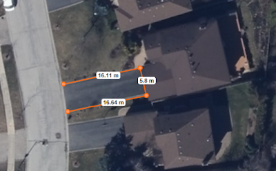
This means all overhead perspectives are in uniform, You can draw on it, measure objects within the image with extreme accuracy; just like a conventional map.
It is capable of measuring true direction and distances free of any distortions that may have been caused by the aircraft.
What are the Advantages of Orthophoto Imagery?
Orthophotography has enormous potential, and is starting to take the role as an invaluable source of data for any projects involving land use and planning.
More Effective:
When you compare it to conventional line-mapping, it is a more cost-effective mapping tool. Further, by using orthophoto data, the speed of the entire process is very quick, making map production extremely efficient and faster then conventional mapping methods.
 |
| Mapping Casa Loma with Orthophoto |
Of course, not everyone has the time to create their own maps, luckily we've done the leg work for you, and you can easily purchase the highest quality orthophoto imagery in Ontario and beyond,
directly from us, ready to use!
Flexibility:
You can store orthophotography in a variety of formats, this facilitates collaboration and sharing of information.
Universal:
One major benefit of using orthophoto imagery is the universal nature of the map. Anyone that views the orthophoto map instantly understands what the map is displaying. Often, features such as a legend are unnecessary because of the low learning curve and universal understanding of the map.
Reliable:
Orthophoto imagery is also reliable. Not all sites are accessible by people to create a map. However with orthophotography, accurate and scaled remote viewing and mapping is very much a reality.
 |
| Imagine measuring sites, without visiting! |
Orthophoto Imagery: the Cornerstone of your Data.
Orthophoto is perfect to use as the base layer for your data, for all the reasons noted above. You will quickly find that in combination with other mapping data, orthophoto imagery quickly adds value to any project.
We all know a solid foundation is critical in any project, and orthophoto is absolutely perfect for this.
First Base Solutions
Our orthophoto imagery is extremely high resolution, higher then any other provider, and our imagery is always taken on days free of snow, cloud, and foliage so you can see the features on the ground clearly!
Click on our link below to check out the latest
orthophoto promotions!


Comments
Post a Comment