WMS? TMS? WMTS? MapCast Subscribers Take Your Pick
 An explanation in plain English without the WTF

As a new subscriber to MapCast, you'll need to connect to the service before you can get to work. On the MapCast dashboard there are five options. Here I'll recommend which connection type to use and when.
Your service connection type will depend on the software you plan to use.
First, a quick overview of what you can do with MapCast based on the connection type you choose. In all cases, MapCast delivers image tiles at various scales which are displayed in turn as the user zooms in or out. The user has access to view the data, not direct access to the data itself, therefore, it can not be manipulated, saved or edited.
Secondly, the step by step instructions to set up the connections are generalized below.
To use the services, add data to your project and choose a connection type.
Your service connection type will depend on the software you plan to use.
First, a quick overview of what you can do with MapCast based on the connection type you choose. In all cases, MapCast delivers image tiles at various scales which are displayed in turn as the user zooms in or out. The user has access to view the data, not direct access to the data itself, therefore, it can not be manipulated, saved or edited.
Secondly, the step by step instructions to set up the connections are generalized below.
 |
| Overview of MapCast connection types |
CAD and GIS
CAD and GIS Users (WMTS and WMS) Overview
Using desktop software allows the user to view the MapCast layers in combination with geodata layers from multiple sources and use the software's built in tools. MapCast is treated in a similar way to any other layer. It can be turned on and off, transparency can be adjusted and the drawing order can be changed relative to other layers. Unlike other layers, the MapCast connection can not be queried or used to clip out and save portions of imagery as a new layer to save locally or print at high resolution. Options to restyle the MapCast layer are not available.Connecting For CAD and GIS Operators
WMTS is usually preferred over WMS because the map image is delivered in many small tiles that are cached by the client which makes the map draw faster whenever you pan or zoom. Which version of WMTS you use will depend on the specifications of your software. Virtually all desktop mapping software will support at least one of the WMS and/or WMTS services, so consult the software help files for compliance details.To use the services, add data to your project and choose a connection type.
 |
| Connecting to MapCast with ArcGIS |
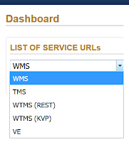
From the drop down menu on your MapCast dashboard, copy and paste the WMS URL for WMS connections, or copy and paste the WMTS URL for WMTS connections.
 |
| Choosing a connection type from the MapCast dashboard |
Google Earth
Google Earth Users (KML) Overview
Using Google Earth allows the imagery layer to be rotated, unlike the other two options. Options for temporary places that control display are available. The seamless coverage can be broken out into groupings based on geographic regions and year which can be turned off and on individually.
Connecting For Google Earth Users
For MapCast subscribers without access to GIS and CAD software, Google Earth is the simplest way to connect. Once you've logged in to the MapCast dashboard, go to the KML Files tab on the right side of the page. |
| Choosing a kml file from the MapCast dashboard |
The kml files are arranged by geographic region. Choose your area and download the kml for it. Open the file in Google Earth and the imagery will load in position on the globe automatically.
Watch a tutorial
Google Maps and Bing Maps
Google Maps Users (TMS) Overview
Imagery is from the newest available data set. The transparency is set at 70% opaque by default which allows text and vector features from the base map below to show through the imagery, but this can be adjusted in the code. Limitations of using this option are that small changes to the how the imagery is displayed can not be done on the fly. The imagery is either off or on, with no option to view historical imagery or overlay contour lines that are available in the WMS and WMTS connections. One advantage is that Google's Streetview and other built in tools are available to enhance your map based research.
Connecting For Google Maps and Bing Maps Users
The other option for using MapCast without CAD or GIS software is to use a tile map service in a standard internet browser. From the MapCast dashboard, go to the Help page and choose the Code Samples Tab. |
| Choosing a code sample from the MapCast dashboard |
From here, decide if you plan to use Google Maps (Recommended for most users), Bing Maps (Recommended for Virtual Earth users), or Open Street Maps. Copy the code for your selected base map and save it as an HTML file. Open the file with an internet browser and the chosen base map will load with the MapCast aerial image layer over top.
Watch a demo: Rarely Asked Questions: How To Use A Tile Map Service
Need help?


Comments
Post a Comment