Posts

Showing posts with the label facility management

Decision Guide: Ground or Aerial Survey?

Image
Quick Answer: Both! Detailed topographic mapping from our MapWarehouse archives is popular with civil engineers to model terrain in 3D. Users can predict the flow of surface water, air movement, acoustic modeling, sight line analysis, make volumetric calculations, and even show depth on a flat image when used together with orthophoto. Most big projects, however, also have a ground survey component. Why buy DEM or contour mapping if you need a survey anyway? One's not better than the other, they both have their place in the project life cycle. Take a detailed look:
Crash Course: Elevation Imagery

Image
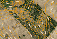
Sample contours map Find the right elevation imagery for your needs Elevation imagery from FBS is usually sold as either DEM with spot heights and break lines, or, as 1m interval contour lines derived from those DEM, but, we have a few other products you might not know about. As you can see in the chart, there are five products that you can extract elevation data from. Each has different types of deliverable's, precision, and geographic coverage:

Quote Fencing Installation Jobs Quickly

Image
VuMAP opens the gateway to efficient project planning Pop quiz: A customer contacts you for a quote to install fencing. What do you do next?

Refine Your Infrastructure Maintenance Process With Aerial Imagery

Image
Tank crude communication methods Follow our crew as they bravely travel great distances and battle the perils of the wilderness, blazing sun, and mosquitoes as big as your head to inspect remote infrastructure...the old way.

Is Your Maintenance Crew On Par?

Image
Get the big picture with aerial imagery Follow our crew as they bravely travel great distances and battle the perils of the wilderness, blazing sun, and mosquitoes as big as your head to maintain trails, irrigation equipment and remote facilities...the old way.

Paving The Way For Profit

Image
Optimize business processes immediately with hands-on mapping technology Pop quiz: A commercial customer contacts you for a quote to repave a parking lot. What do you do next?

Three Ways Aerial Imagery Helps Real Estate Pros

Image
Sales, maintenance, assessments There are many ways to be a real estate professional.  Any kind of land based research, management, or analysis can be enhanced by adding high resolution aerial imagery to your day to day tasks.

Options For Managing Infrastructure Networks

Image
Solutions for energy, utilities, service delivery, infrastructure and more. It doesn't matter what you're delivering, if you have widespread networks and facilities to monitor and maintain, you need a fool proof system in place to stay on top of it all. First Base Solutions is a provider of off the shelf and custom mapping solutions to fit your business needs, technical ability and budget.