Posts

Showing posts from 2018

Wrapping Up 2018

Image
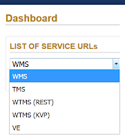
What's new, what's coming In 2018, we accomplished important behind-the-scenes work in preparation for the upcoming launch of MapCast 2.0 in 2019. We also got to work developing relationships with data providers to bring new value-added mapping products to our MapWarehouse store as well as producing a library of mini tutorials to help you use them.

Tips To Sell Your Boss On MapCast

Image
Fill out a requisition and hope someone signs it, or... You see the value in the service, but how to convince someone else? Leverage the rapport you have with your manager combined with the tips below to get your company on MapCast . Here's how to talk to your boss like a boss. If The Boss Says...     "The way we've always done it works fine." Change is hard, there will be resistance. Your boss probably spent a long time and lots of money on getting the current system running as well as it does and feels hesitant to throw it away. The 'ain't broke, don't fix it' strategy doesn't usually cut it when it comes to technology though.

How To Remove An Item From Your MapWarehouse Shopping Cart

Image
Still a top question after all these years! You need to review your shopping cart before heading to the checkout. The tools to do this are hiding in plain sight. Before placing that angry phone call, please watch this one minute video. Related: Using MapWarehouse [Video]  

RAQ: Getting Started With LiDAR

Image
Start with a free sample file LiDAR (Light Detection And Ranging) is a technology that essentially takes pictures using laser pulses instead of visible light. You've likely heard about LiDAR in the context of self-driving cars, since the returning laser pulses from a car mounted LiDAR system produce a point cloud telling the car about objects around it in three dimensional space. By using a LiDAR system mounted on an aircraft, the three dimensional information can be used to create topographic maps of the terrain below. Bare earth elevation models are available on MapWarehouse in GeoTiff format. They are easy to use and highly accurate at +/- 10cm. Download the sample file and follow along with the video below to get started with LiDAR.

RAQ: How To Get The Newest Data First

Image
Is it ready yet? ...How about now? ...Now? The aerial imagery collection window in Ontario is short for the most popular leaf-off ortho products, around 6-8 weeks. Typically we can start flying in late March and it all wraps up by early May, weather dependent. In this time frame we cover a lot of ground, often capturing imagery for several municipalities. Once the intense flying season is over, the next six months are spent back at the office processing the raw images into an application-ready mosaic and posting the data to the MapWarehouse store, VuMAP , and MapCast . During this six month period we frequently get asked, "Is it ready yet? ...How about now? ...Now?" There are three ways you can keep in the loop when new data is released.

RAQ: How Does Image Resolution Relate To Map Scale?

Image
Will it Work?  First, 20cm imagery is not the same as 1:20 map scale. Maps are created with mix and match combinations of data sources. Each source may be fine on its own, but will the information make sense in the final composition? If you trust the source data providers are reliable and you've got a handle on the datum and projection issues but the finished map looks awful, consider mismatches in scale.

Dear FBS, What Does Aerial Imagery Have To Do With Baseball?

Image
Dear First Base Solutions, Your company does aerial imagery and mapping services, so why does your name sound like a baseball company? Another rarely asked question, and one we're happy to answer. You see, 'Base' as in 'First Base' comes from 'Base Mapping', as in, our data is the 'First Base' layer for your project. Our 'Solution' is to enhance decision making for projects in any industry through the use of reliable, high quality information. I Thought A Base Map Was The Same As A Topo?

Ready, Set, Research! [Video]

Image
RAQ: How to export details of your saved research from VuMAP to a spreadsheet. For a lightweight application, VuMAP sure does some heavy lifting when it comes to day to day productivity in your real estate or law practice. Today's rarely asked question highlights a simple but powerful built-in tool that will help speed up your research; the query tool. Find the location on a map Query to review the attributes of features in the area Bookmark the chosen features Save the attribute information to a spreadsheet   The video below will show you how, and lets you preview the property parcel features you won't see with a free trial subscription.

A Planet Sized Data Delivery - Now Available!

Image
Introducing Our Newest Data Partner: Planet Labs Geomatics There's a million new reasons to choose MapWarehouse. First Base Solutions has entered a new reseller agreement with Planet Labs Geomatics , a provider of commercial satellite imagery, to bring over 1,000,000 square km of new Ontario imagery to MapWarehouse , and that's just the beginning!

WMS? TMS? WMTS? MapCast Subscribers Take Your Pick

Image
An explanation in plain English without the WTF As a new subscriber to MapCast, you'll need to connect to the service before you can get to work. On the MapCast dashboard there are five options. Here I'll recommend which connection type to use and when. Your service connection type will depend on the software you plan to use. First, a quick overview of what you can do with MapCast based on the connection type you choose. In all cases, MapCast delivers image tiles at various scales which are displayed in turn as the user zooms in or out.  The user has access to view the data, not direct access to the data itself, therefore, it can not be manipulated , saved or edited.

Rarely Asked Questions: How To Use A Tile Map Service

Image
If you can use Google Maps, then you're already an expert. It's much easier than you think. What's a TMS? TMS is a Tile Map Service. Aerial imagery from our planes is processed to create a highly detailed photo map that covers Southern Ontario. A grid is used to split the photo map into thousands of small tiles.

Zoom2It Demo [Video]

Image
How to search for Ontario aerial imagery with Teranet property boundaries If you're new to Zoom2It , welcome! The most common questions from new users include 'How do I get the images I just bought' and 'How can I open this file?' Here's a few quick hints.

Decision Guide: Ground or Aerial Survey?

Image
Quick Answer: Both! Detailed topographic mapping from our MapWarehouse archives is popular with civil engineers to model terrain in 3D. Users can predict the flow of surface water, air movement, acoustic modeling, sight line analysis, make volumetric calculations, and even show depth on a flat image when used together with orthophoto. Most big projects, however, also have a ground survey component. Why buy DEM or contour mapping if you need a survey anyway? One's not better than the other, they both have their place in the project life cycle. Take a detailed look:

Decision Guide: Drone or Fixed Wing Aerial Imagery

Image
A quick overview Technology keeps advancing and drones are no exception. If you need aerial imagery for your commercial applications you've probably considered using drones or drone imaging service providers at some point.  Here's some tips to guide your decision.